Whether you’re planning routes ashore or navigating offshore, qtVlm is a high-performance navigation software designed for sailors who demand precision, reliability, and analytical depth —qualities it shares with SailProof devices. With SailProof devices, qtVlm becomes even more powerful, giving you a complete, professional navigation experience from the moment you step on board.
qtVlm may seem like an enigma—its letters often puzzle sailors—but the name actually comes from the combination of Qt, the development framework, and VLM, referring to the Virtual Loup‑de‑Mer project, the historic foundation of this advanced routing software. Here, we will explore all the capabilities of adding this powerful tool to your sailing software library, showing how it can enhance route planning, weather analysis, and onboard decision-making for every sailing journey.
What qtVlm Offers for Sailors
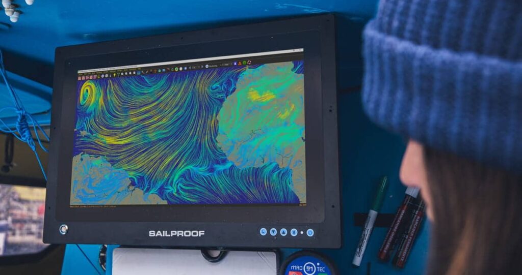
qtVlm is a high-performance navigation software designed specifically for sailors who want full control of their navigation, both during route preparation and at sea. Oriented toward sailing, qtVlm always takes wind data and boat performance into account through the use of polar diagrams. These performance data are fully integrated into routing, planning, simulation and even the replay of recorded navigations, allowing sailors to analyze, optimize and understand their sailing decisions in depth.
qtVlm combines advanced routing algorithms with detailed weather visualization and a wide range of professional-grade navigation tools. It integrates AIS for real-time traffic awareness, NMEA data for seamless onboard sensor connectivity, and supports multiple weather models and GRIB files for accurate forecasting. Available on multiple platform, qtVlm adapts to different onboard configurations and sailing styles.
Expand Your Sailing Options
qtVlm also provides additional options to enhance your navigation experience, including features like Meltemus chart packs and GRIB subscriptions. These extras not only enhance your capabilities on board but also create new opportunities with qtVlm, giving you even greater control over your sailing experience:
Chart Packs for Your Sailing Areas. Meltemus chart packs are digital navigation charts designed for use exclusively with qtVlm on all supported platforms. They provide detailed coastal, port, and depth information, keeping sailors up-to-date with regular updates. On Android a full version of qtVlm is required to display the chart packs, turning any compatible device into a professional navigation tool.
GRIB subscriptions for advanced weather forecasting. qtVlm supports GRIB files, which provide highly detailed weather data including wind, waves, pressure systems, and currents. With a GRIB subscription, sailors can access up-to-date weather forecasts for their sailing areas, plan routes more efficiently, and make informed decisions while at sea.

QTVLM from your SailProof tablet or touchscreen
Whether you’re using our tablet or your PC with Windows for navigation, qtVlm is available to make your routing plan smoother. You can take advantage of the tablet, which can be set up anywhere on your boat, or use a larger display connected to your laptop if you prefer. This allows you to visualize routes, weather, and AIS traffic on a large, sunlight-readable screen.
With both the tablet and Windows versions, you get a solution that adapts to your boat, your style of sailing, and your onboard setup. From SailProof tablets ready to sail, to large touchscreen displays in the cockpit, qtVlm ensures your navigation is accurate, reliable, and professional-grade.
Whether you’re a cruiser, offshore sailor, or racing enthusiast, qtVlm on SailProof devices gives you everything you need to plan, navigate, and optimize your sailing. We are also excited to announce that, thanks to our partnership with qtVlm, if you buy a new tablet, you will receive the full version free for life on your device.


