Weather is the most crucial component of sailing and is a decisive factor for safety, comfort, and the successful implementation of any sailing trips or races. Nowadays, technology and innovation have progressed so far that with just a little basic knowledge and understanding, most of us can make informed decisions based on the available weather forecast.
Before we dive into more specific applications, let’s explore a little into the world of weather forecasting and weather models. As you might already know, weather forecasts are based on sophisticated numerical models (GFS, ESMWF, etc.) that update every few hours. These models all work with the same equations that define the dynamics of our atmosphere and its interactions with land and sea. The biggest differences are the spatial and temporal scales the models use, or simply whether they are global or local. Other differences can be found in the way the initial conditions are set and calculated, while the validation and interpolation practices used by the models can also slightly vary.
What is also important to note is that most, if not all, forecast data is available for free from major meteorological institutes globally and regionally. However, the data is often only available in a ‘rawer’ format and is not easy for most of us to find and visualize in a practical and useful way. This format is often known as GRIB files, which we will explore below.
Private weather companies/applications access and link this freely available data to their websites, creating animations, graphs, overlays, and much more. The forecasted weather is usually nearly identical when looking at the same models on different providers (observed differences should be minimal and caused either by different interpolation methods, different model run times, or different spatial/temporal resolutions of the used data set). It’s very unusual for any weather provider/app to run their own numerical models. Sometimes they will apply small alterations or run small spatial/temporal simulations to represent local areas better, which can often improve localized forecasts immensely. The physics or meteorological institutions of individual countries will run their weather models based on the global models with much smaller spatial and temporal resolutions and a much better representation of the topography of the cover area. It is therefore always advisable to explore such models when easily available.
What are Grib files and how do you use them?
Maybe you have already heard of Grib files or even used them. Nevertheless, for the uninitiated, GRIB stands for “General Regularly distributed Information in Binary form” and is a WMO (World Meteorological Organisation) standard format for archiving and exchanging gridded data. As a binary format, the data is packed to increase storage efficiency. GRIB messages are often concatenated together to form a GRIB file. They usually have the extension .grib, .grb, or .gb.[ECMWF]. The younger generation might not be familiar with those files, as widespread high-speed internet and the development of weather apps remove the burden of finding, downloading, and visualizing the files efficiently. However, weather apps only work when online and use a considerable amount of data, which can become prohibitive when using an Iridium or SSB radio. It’s in this type of situation that GRIB files come in handy. Numerous apps will allow you to easily access, download, and visualize GRIB files for specific areas and time frames from various sources, minimizing data usage and time.
Furthermore, the data is then downloaded and stored on your device for later offline use. Some apps will already help configure downloads via your Iridium Go or SSB. Lastly, GRIB files are not only available for forecasted weather, but historical forecast data can also be accessed for more in-depth planning.
After years of collaborating with Henri Laurent from SailGrib, he has launched a new application: NavimetriX, a multi-platform app specialized in advanced weather routing. Created alongside Olivier Bouyssou, NavimetriX evolves from eSail4VR, the acclaimed Virtual Regatta companion app used by tens of thousands of sailors during the 2024 Vendée Globe. NavimetriX allows users to analyze multiple forecast models, optimize their route based on real conditions, and sail with confidence, ensuring that every decision is guided by precise meteorological data.

Sailing weather, passage, and weather routing
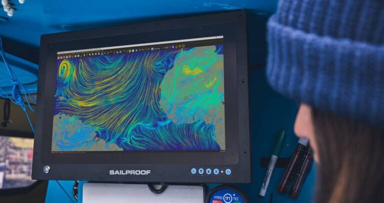
SailProofs marine rugged tablets and touchscreens are designed by sailors for sailors. They can handle any situation and need on your sailing adventures, including running the most demanding routing and weather applications. This helps sailors make the right decisions to stay safe, comfortable, fast, and efficient. Many sailing applications include not only cartography but also weather info and even weather routing. Depending on the app and the passage you are planning, this information might be sufficient. But in case more details are required, it’s often advisable to use a more dedicated weather application, such as Windy, Predict Wind, or a GRIB file reading weather app, which can provide you with a general weather overview of the area of interest. Obtaining a forecast for day trips can be rather simple. But on a multi-day journey, things can become trickier and often require a more sophisticated approach.
Using apps that allow boat-specific polars running detailed simulations through time and space is often the only way to get reliable forecasts for the expected positions during the passage. These calculations ensure more precise route planning and optimizations, with the simulation of various scenarios, such as different ETDs, speeds, various route options, and even sail settings. Therefore, taking your sailing to the next level, both in terms of safety and performance. Applications with more sophisticated calculations include NavimetriX, qtVlm, Predict Wind, C-Map, etc., and, to a lesser extent, the Windy desktop and mobile application which lets you input a simple route and simulate the weather along it at constant speeds.
Tips to consider when planning a passage
–Overall weather. Watch out for high CAPE index and thunderstorms, deepening low-pressure systems, and, in relevant areas, the development of tropical storms, swells, and fog.
–Average wind and wind gusts. Compare all available models and only set sail if you are comfortable with the forecast gusts. Large discrepancies between models as well as between gusts and average winds can be an indicator of unstable conditions.
–Waves and Swells. If you are sailing in a large ocean, the direction of the swells might not concur with the direction of the wind waves. In fact, there can be the so-called primary swell, secondary swell, and wind waves, all coming from different directions and often difficult to read on a forecast. A long-period swell can have little to no effect in deep waters but can make a shallow port entrance dangerous. A short-period head swell, on the other hand, can make progress hard and extremely uncomfortable, so make sure to check carefully.
–Tides and Currents. Tides are often strongest along narrow passages and near the coast and can create some nasty conditions when going against the prevailing conditions. However, currents can take the form of either localized or vast oceanic features, like the Gulf Stream. Knowledge of them is essential to avoid their adverse effect or to turn them into a positive push in the right direction.

(c) SailProof
Weather at Anchor
Finding a protected anchorage can be a huge challenge, especially in certain areas. Your first step will be to consult your charts, pilot books, and community apps, such as those we explore here. Once the desired spot is identified, one must check the expected conditions for the planned time frame. This can be achieved with any of the means mentioned above, but also by consulting local sailors, pilot books, etc. Local topography can often create localized conditions (e.g., gusts and reflecting swells) that’ll make a seemingly perfect anchorage a nightmare.
Tips for anchoring
· Check all available forecasts for indications of bad weather, and look out for discrepancies between models, heavy gusts, high CAPE index, thunderstorms, tides, swells, and waves (swells created by far-away storms can travel hundreds of kilometres, and ruin or even make an exposed shallow anchorage extremely dangerous).
· Always set your anchor like a storm is coming – i.e., test it, especially if leaving the boat unattended. Conditions can change rapidly and might not be represented even in the more detailed forecast.
· Set an anchor alarm, with SailProof tablets great connectivity is guaranteed, leave your SailProof with a SIM card on board and receive any alarms on your smartphone.
· Talk to other sailors, fishers, and locals about the anchorage.